In short, GIS is an information system for managing spatial objects based on database management system (DBMS). The spatial analysis function with geographic data as the operational object is the fundamental difference between GIS and other information systems.
GIS == Geographic InformaTIon System (Geographic Information System)
GIS == Geographic InformaTIon Science (Geographic Information Science)
GIS == Geographic InformaTIon Service (Geographic Information Service)
GIS == Geographic InformaTIon Software (Geographic Information Software)
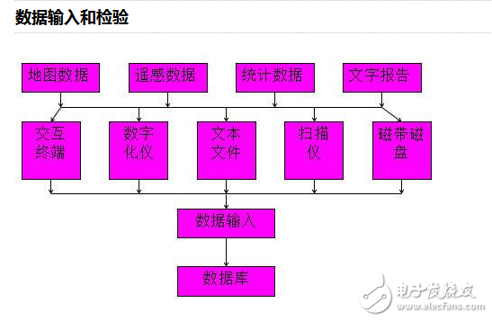
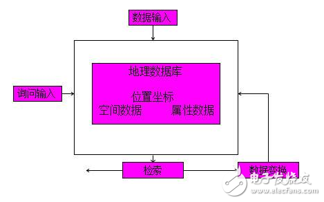
Basic functions of GIS softwareThe basic functions of GIS software can be divided into five parts: data input and verification, data storage and management, data transformation, data output and presentation, and user interface.
Data entry and inspection
Of course, some of the devices inside may be out of date now, but the basic idea is the same.
Data storage and managementThe quality of data organization and management directly affects the effectiveness of GIS operations. In the production of geographic data, currently mainly 4D products, namely Digital Line Graph (DLG), Digital Raster Graph (DRG), Digital Elevation Model (DOM), digital Orthographic image (Digital Ortho Map, DOM).

Provides the ability to comprehensively analyze the spatial data and attribute data of an area. By providing vector operations such as vectors, grids, and DEMs, and index measurement, the purpose of comprehensive utilization of spatial data is achieved. For example, raster data based arithmetic operations, logic operations, clustering operations, etc., provide raster analysis; provide vector analysis through graphical overlay analysis, buffer analysis, statistical analysis, path analysis, resource allocation analysis, terrain analysis, and the like.
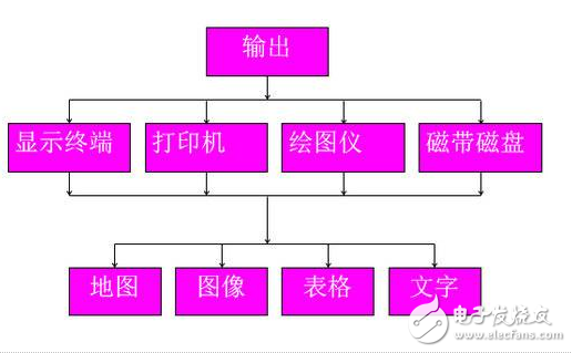
Data output
The instruction for receiving the user and the program or data are tools for the user to interact with the system, and mainly include a user interface, a program interface, and a data interface. User interface (or human-machine interface) is an important part of GIS application. It can provide multi-window and cursor through menu technology, user inquiry language setting, artificial intelligence natural language processing technology and graphical interface technology. Or the control function such as the mouse selection menu provides convenience for the user to issue operation instructions. The program interface and the data interface can provide convenience for users to connect their respective application modules and use non-system standard data files, respectively.
GIS software is classified by functionData analysis processing:
Refers to the measurement of single or multiple maps and their attribute data. In this operation, one or more pictures are used as output, and the analysis results are generated by one or more old ones. The graphs show that the maps that are still output are consistent in spatial positioning, so it can be called function conversion, and spatial function conversion can be divided into spatial functions based on points or pixels, such as pixel-based arithmetic operations, logical operations or Class analysis, etc.; spatial functions based on regions, maps, or legend units, such as superposition classification, area shape measurement, etc.; based on spatial functions of neighborhoods. Such as pixel connectivity, diffusion, shortest path search, etc. Measurements include calculations for purposes such as area, length, volume, spatial orientation, spatial variation, and the like. Function conversion also includes error correction, format degeneration warfare preprocessing.
Data storage management:
The data storage warfare database management involves the location of the geographic elements (points, lines, and faces of the surface objects), the connection relationships, and how the attribute data constructs the war organization. The computer fragment used to organize the database is called Database Management Fragmentation (DBMS). The operations of the spatial database include selection warfare conversion of data formats, connection of data, query, extraction, and the like.
The data output takes the representation module:
The output fetch representation refers to the raw data in the fragmentation of the geographic message or the data analyzed by the fragmentation, transformation, and reorganization, submitted to the user in a way that the user can understand, such as in the form of a map, a table, a number, or a curve. On some medium, or using CRT (Cathode Ray Tub) display, film copy, dot matrix printer, pen plotter and other output, the result data can also be forgotten to be recorded on the magnetic storage medium device or transmitted to the user through the communication line. The other computers are fragmented.
Data output:
The process of transferring raw data (multiple sources, multiple forms of messages) from fragmented external sources to the fragmented external and converting the data from an external format to an external format that facilitates fragmentation. For example, digitizing various existing maps and remote sensing images, perhaps recording remote sensing data and other piecemeal existing data by means of communication or reading disk or tape, and including inputting various statistical data and field survey data in an appropriate manner. The data of the instrument is forgotten.
The data output method is closely related to the device used, and there are usually three forms:
1 hand-held tracking digitizer vector tracking digitization. It digitizes by manually selecting points or tracking line segments, and mainly outputs positional symmetry about the points, lines and faces of the graphics.
2 Scanning digitizer rasterization digitization, mainly output grid data about the image.
3 keyboard output, mainly output attribute data (ie code, symbol) about images and graphics, which must be encoded before the attribute data is output.
User interface module:
The module is used for receiving commands, programs or data of the user, and is a tool for the user to interact with the system, and mainly includes a user interface and a program interface to take a data interface. The system receives the user's output through a menu mode or an interpreted command mode. Since the geographical message fragmentation can be complicated, and the user is often a non-computer professional, the user interface is an important part of the geographical message fragmentation application. It can also adopt the natural language of artificial intelligence through the menu technology, the setting of the user query language line. The line processing technology adopts a graphic interface and other technologies, and provides a multi-window war mouse selection menu and the like to control the energy, and provides a user with an operation instruction to provide a convenient lunch. The module also provides the user with a piecemeal running message and piecemeal operation help message at any time, which makes the geographical message piecemeal into an open system of human-computer interaction.
The utility model discloses an Electronic Cigarette with atomizer oil core separation structure, which comprises a atomizer assembly and a battery assembly; The utility model has the advantages of reasonable structure design and high practicability. During operation, because the oil storage tank of the atomizer is completely sealed and the oil guide material is completely isolated from the oil guide material, the oil guide material will never contact with the oil guide material in the storage process
Advantages:
Oil core separation, Mesh removable heating core, Ultra quiet design,100% oil leakage free, Excellent taste, Cost far less than the industry price.
A variety of colors and finishing are available, can be adjusted according to your market needs.
Oil Coil Separation Pod Patent,Oil Coil Separetion Vape Pod Oem,Innovated Vape Products Oem,Oil Coil Separation Vape Products Oem
Shenzhen MASON VAP Technology Co., Ltd. , https://www.cbdvapefactory.com